
Dong Tam/My Tho 2001
Photos from Lt. Houghton's trip to Vietnam
![]()
As I write this it is Sunday and I have just returned from visiting My Tho, Dong Tam and Can Tho. There is a heavy rain falling outside my room - an absolute downpour. The delta is getting ready to enter the wet season.
Let me begin with Saturday morning. My group decided to join me for the weekend so we rented a van, driver and guide and left Cao Lanh around 8:30 AM. After a 2 hour ride, we came into My Tho from Hwy. 1, driving down the old main drag to the city. While I didn't recognize anything specific, it did feel like the My Tho of old with it's many buildings and tree shaded streets. We arrived at the government run tourist docks for what would be a boat ride on the Mekong river. Our boat ride took us to Dragon Island where we got into smaller motor driven sampans for traveling the small canals. Now, let me tell you, that was a little spooky. I was now back in old familiar territory, the boonies if you will, the Vietnam we all remember. The canals were narrow, shaded by overhanging coconuts trees and the banks were lined with nipapalm. As soldiers, we struggled to cross many of these canals daily, fighting the unyielding nipapalm and the foot sucking mud up to our knees. We tried to take "giant steps" as it took much effort to pull your trailing foot out of the mud at the expense of your leading foot being driven down with the shifting of your weight. It often took a half hour to cross a 20 yard wide canal, only to be greeted by the tangle of nipapalm on the other side. We would try to cut it with our bayonets but it was still a struggle as we often got our feet wedged into the crotch or two nipapalm plants growing side by side. We were always especially vulnerable to sniper fire as we exposed ourselves in the openness of the water and had no where to go if it happened. Haunting memories!


1 - Canal with local Vietnamese heading to
market - These dugouts would have been searched by the MRF for weapons in the
late 60s
2 - Narrow canal - as LT Houghton says, just makes you nervous looking at it.
Crossing a canal, the point man was exposed, and M60s/Thumpers were ready. Air
mattresses at high tide (if you had them)
To continue, we arrived at a small government run tourist destination where people get to visit a "typical Vietnamese house." Perhaps! It looked pretty upscale to me, nicer then most that we saw. We did get to eat numerous fruits and some coconut candy that is made there. I got to drink some rice wine and some coconut wine ( both were distilled to about 60% and tasted more like a brandy). It had an orchard there with many small irrigation ditches interspersed between the rows of trees. The humidity hangs heavy over everything and the familiar smell of small wood fires and charred ashes was ever present It is indeed a small community like we knew.


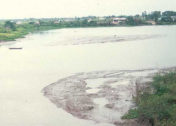
Photos of the Ben Tre side of the Song My Tho
near the old ferry site

The hotel that LT Houghton stayed in while
visiting My Tho
After the Fruit farm, we turned to the main body of the Mekong where we re-boarded our larger boats to head in the direction of Dong Tam, on the Ben Tre side of the river. I passed the Ben Tre ferry landing from a distance and noted that today there are about 6 to 8 boats running continuously. They look the same as before. I passed what is know as "Coconut Island." Many of us remember it as "Little Disneyland" as it was a large colorful theme park looking structure on a small Island between My Tho and Ben Tre. We used to pass it on the ferry ride. Apparently during the war it was occupied by a religious monk who was a pacifist and ate only coconuts for three years. I am told that during the war, over 5000 men lived there from time to time in an effort to avoid being conscripted into the South Vietnamese or VC armies. At the end of the war the monk was imprisoned by the victorious communists and put in prison for "subversive activities" where he eventually died
an old man. Today, the structure is in shambles. The colorfully painted structures are falling down the paint faded and you have to use your imagination to realize it was the "Little Disneyland" of our past. It is a tourist area today, but viewed as an oddity with a great story line by most who visit it. 


1 - Ferries at Phoenix Island better known as
Little Disneyland - they run between Ben Tre and My Tho
2 - Road leading to old My Tho ferry site
3 - Old My Tho ferry site
As we continued toward Dong Tam, We pulled off onto the Ben Tre side of the river to a new restaurant set up for the tourists. It has beautiful outdoor structures to eat in, and the small buildings are surrounded by lush, well kept, gardens and fish ponds . We had another incredible lunch there and were entertained by a three piece band, if you will, playing traditional and primitive instruments. They still sing in high pitched, nasal voices. After lunch we completed the river cruise and returned to My Tho.
From My Tho, we drove on toward Dong Tam, passing the old ferry landing we used to depart from to Ben Tre. It still looks very much the same as before, nothing that I remember specifically, but all very familiar. About a Kilometer past the ferry landing there is a new "Fosters" brewery being built as a joint effort between Vietnam and the Australians. It will be enormous and of course modern and will stand out as an anomaly in relation to the surrounding old architecture. It lies next to the Mekong river and is clearly visible from the water.


1 - The new Vietnamese Army main gate to Dong Tam
2 - Sign for Snake Farm located just outside Dong Tam
3 - Cobras inside the Snake Farm
Finally- Dong Tam! I never actually got onto the Don Tam we knew as Ninth Infantry soldiers Remember the dump at the Dong Tam gate? Well, it is now a snake farm. It is located just outside the gate on the left as you would have entered. It was built by a former VC officer at the end of the war. It contains king cobras, spitting cobras, pythons, water snakes and Bamboo pit vipers, all in cages or open pits. The guides give a demonstration of how to make a cobra come to attention by poking them. It is interesting to see them rise up with their characteristic hissing sound. Since the former officer died, the farm has gone down hill. Today it is mostly a tourist area and doesn't appear to be generating much money from the sale of Venom or snake meat. It continues to be run by the army.


1 - Photo of the Navy Basin taken from a
bridge not far from the location of the old ammo dump
2 - Catholic orphanage outside of Dong Tam
3 - Area of the main gate to Dong Tam circa 1969
4 - Road leading to Dong Tam main gate
The Dong Tam army base as we knew it, sitting on an elevation of sand dredged from the Mekong River, is today a Vietnamese army and navy training center. I saw the gate to the base and of course took photos of it in a discrete way as it is a military instillation. The entrance is now covered by an arch, painted red and with typical communist yellow letters identifying what it is. There is a swinging gate under the arch and an adjacent small guard house, manned by an armed soldier. I am told that, as an American, I would not be allowed to enter it. I talked to one of my guides who told me he had been there for training and that his brother is there now. Apparently all the wooden structures we built are now gone. They were torn apart and salvaged by the locals when the 9th pulled out in '71. (webmaster's note: the 9th pulled out in late August 1969) Anything left standing ultimately rotted away. Today the buildings are made of cement blocks, are single and two stories and apparently number in the hundreds. The old navy basin is still there and many of the old gun boats (PBRs) remain along with ATCs (tango boats). (webmaster's note: a second visit by Charles to Dong Tam showed NO PBRs or other boats in the Navy Basin). Apparently there are other US army weapons and ordinance there as well. The landing strip is still there but seldom used as are the old helicopters which are too expensive to operate and are in disrepair. There is little need for them in peacetime Vietnam. Only occasionally are the PBRs and tango boats seen on the river. Apparently there are several sunken ATCs and PBRs located around the delta, many sunk after the Americans left. Even today, people remember where they are and they have apparently been stripped by the local divers for their metal and guns.
![]()
![]()
Photos of the Navy Basin at Dong Tam Base Camp -
March 2001
1 - Southwest Dong Tam looking NNE
2 - Enlargement of left side of 1st photo showing the canal
along the west side of Dong Tam. The fixed-wing landing strip was some distance
behind the building shown in the foreground.
3 - The entrance to what was the Navy Basin.
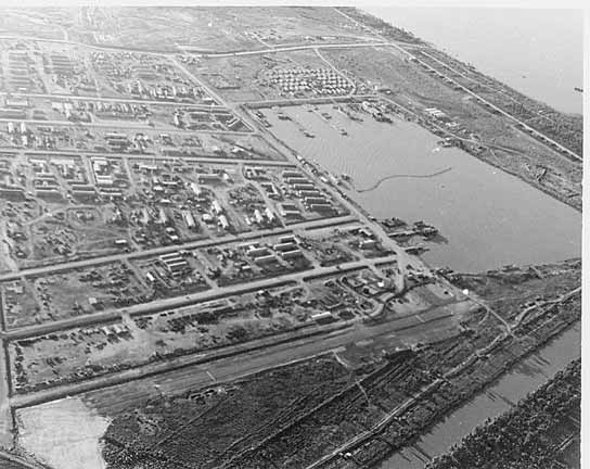
Dong Tam aerial photo of the Navy Basin taken in
1968 - looking SSE. The canal shown in the March 2001 photo is shown in the
lower right of the above photo
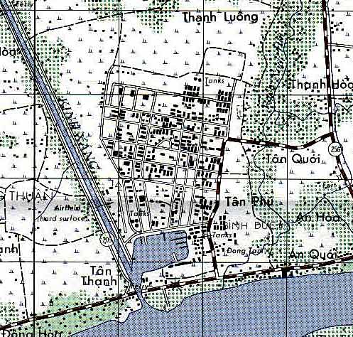
Map of Dong Tam Base Camp - north is up. LT
Houghton took the March 2001 photo while standing on the bridge that crossed the
canal (bottom of map, slightly left) shown on the map
To continue, there is a tall communications tower in the middle of the base now, several hundred feet tall and visible from many clicks away.
My impression from looking at the base camp from outside is that all those palm trees that the colonel had us plant around the the battalion area finally took hold. It looks to be well vegetated. Apparently the berm is still present although the old sand bag bunkers and command posts are now gone and replaced by newer ones. The concertina wire has been removed as have the mines that surrounded the base camp. In any event, it was a surprise to learn that the camp, as we knew it is still there, Rumors had it that the snake farm was built on the old base camp. Not so, it was built next to it.
After leaving the base camp, I rode out the old road we used to travel to Hwy1. Believe it or not, it appears very much as it did in 68-69. It is still a dirt road, houses here and there and surrounded by rice paddies and patches of coconut trees here and there. The old masonry school that was on the right side of the road as we approached Hwy 1 is still there and active. Memories of the early morning mine sweeps along this road returned. I couldn't help looking for signs of freshly disturbed dirt in the road, in search of what might be "Charlie's" handiwork". It was not difficult to imagine gunfire coming from the wood line. Lt. Pierce Michael used to fly over this road every morning while on the daily S-2 recon flights, looking for the craters the VC blew from the night before.
After about five Km, I arrived at the intersection of Hwy. 1. In the past it was an unremarkable place, perhaps a couple of small vendors there or a house or two. Today, as with the rest of Hwy. 1, it is a congested and densely built commercial area. You'd hardly believe it.
Traveling south on Hwy 1, I looked for what was the old provincial chief's house that was next to the old duck farm. I'm sure it was there, but I was unable to locate it in the midst of all the new buildings.
I will stop here, do a quick edit and then get this off. Once again, I am rushed, a poor typist and inadequate speller, so please don't be too critical of my text. I'll try to rewrite much of this when I return to the "real world".
![]()
To return to the Vietnam 2001, click HERE